Funders: Salmon Recovery Funding Board (RCO), Confederated Tribes and Bands of the Yakama Reservation
Completion Date: May 2023
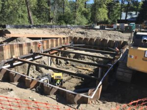
Location: Lower Twisp River, Okanogan County
Cost: $363,970
Outcomes: 3,432 feet of stream treated for channel structure placement, 10 structures placed in channel, 10 pools created, and improved riparian growth.
The Yakama Nation restored a section of the Twisp River by strategically placing large wood structures using helicopters and heavy tracked equipment in an area with substantial connectivity between the river and groundwater. It addressed top priority ecological concerns in the Lower Twisp River Assessment Unit including a severe lack of large woody materials in the river and decreased canopy cover on the bank. The result is increased instream structural complexity, reconnected side channels, increased floodplain connectivity, and restored habitat forming processes that will benefit Upper Columbia spring Chinook and steelhead populations in the long term.
Restoring access to off-channel floodplains and wetlands will provide juvenile salmon with high-quality habitat for rearing throughout the year, including cool, groundwater-fed refuge during periods of extreme heat. The large wood structures will also strengthen connections between the river and its floodplain, encouraging healthier riparian vegetation and restoring the natural hydraulic complexity of the river.